- What is Ozone?
- What is a Dobson Unit?
- What are Ozone Mini-Holes?
- What is the Polar Vortex?
- What is a Stratospheric Warming?
Topics
What is the Polar Vortex?
The stratospheric polar vortex is a large-scale region of air that is contained by a strong west-to-east jet stream that circles the polar region. This jet stream is usually referred to as the polar night jet. The polar vortex extends from the tropopause (the dividing line between the stratosphere and troposphere) through the stratosphere and into the mesosphere (above 50 km). Low values of ozone and cold temperatures are associated with the air inside the vortex.
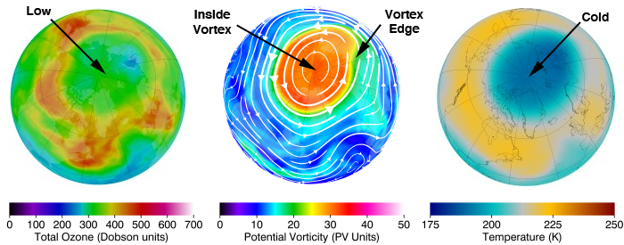
Northern hemisphere total column ozone, potential vorticity on the 460 K potential temperature surface, and temperature on the 50 hPa pressure surface for 22 February 2011. The white lines with arrows on the PV image are streamlines, where the thickness of the streamlines and the size of the arrows indicate the strength of the local flow.
We illustrate the Arctic polar vortex with three images for 22 February 2011. This day is an example of a somewhat symmetric vortex whose center is near the North Pole. The middle image shows potential vorticity (PV) and streamlines on the 460 K potential temperature surface (about 20 km in altitude). The orange-red colors indicate high PV, while the blue-purple colors indicate low PV. The edge of this vortex is the area in the yellow-green colors and is associated with the core of the polar night jet. This jet circles the Arctic region, separating the polar vortex and the midlatitudes, and acts as a barrier to latitudinal transport of air—isolating that stratospheric air over the Arctic. The concentrations of chemical inside the polar vortex are much different than those found outside the polar vortex. For example, air parcels inside the polar vortex have much lower values of CFCs than those found outside the polar vortex. This is because the air inside the polar vortex has descended from the upper stratosphere and mesosphere over the course of the winter, and CFCs are destroyed in the upper stratosphere.
The left image shows total column ozone. The right image shows temperature on the 50 hPa pressure surface (about 20 km in altitude). The highest values of the total ozone column are found near and just outside the polar vortex edge or near the polar night jet. Relatively lower values of total ozone are co-located with the polar vortex. The distribution of temperatures of the lower stratosphere are similar to the distribution of total column ozone. Warmest temperatures are found near and just outside the vortex. During winter, temperatures in the vortex usually drop below 195 K, and polar stratospheric clouds form. Chemical reactions on the surfaces of these cloud particles releases chlorine that originated from CFCs into forms that can rapidly destroy ozone.
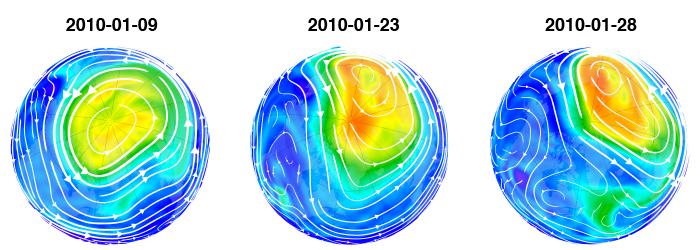
Northern hemisphere potential vorticity on the 460 K potential temperature surface for 9, 23, and 28 January 2010. The white lines with arrows on the PV image are streamlines, where the thickness of the streamlines and the size of the arrows indicate the strength of the local flow.
The stratospheric polar vortex shows quite a bit of day-to-day variability. This variability is caused by weather systems or large-scale waves that move upward from the troposphere into the stratosphere. In the left image (9 January 2010), we see some undulations along the edge of the polar vortex, but the vortex is generally centered on the North Pole. Two weeks later (center image on 23 January 2010) we see the center of the polar vortex pushed away from the North Pole. On a constant latitude circle, PV values are high in the eastern hemisphere and low in the western hemisphere. This is referred to as a wave-1 pattern (a wave-2 pattern can be seen in the vortex breakup section below). The wave-1 pattern develops in the troposphere and moves upward (propagates) into the stratosphere.
These stratospheric waves are forced by the large-scale mountain systems and the land-sea contrasts between the continents and oceans. During the northern winter, these waves are continuously forming and moving upward into the stratosphere. The waves can “break”, much like the waves on a beach. These wave-breaking events erode the vortex and keep the polar region warmer and ozone amounts higher. Often, parts of the polar vortex are pulled away from the main vortex. The image on the right (28 January 2010) shows this, where a large piece of the polar vortex was pulled away from the main vortex (green colored material at the bottom of the image). A comparison between the middle and right images also shows a slight contraction of the polar vortex because of these waves.
Southern hemisphere stratospheric vortex
As with the northern hemisphere and the Arctic, there is also a southern hemisphere polar vortex. This polar vortex also extends through the stratosphere and into the mesosphere. In contrast to the northern vortex, the southern vortex is stronger, larger, and longer-lasting. In addition, temperatures are colder and ozone levels are lower than their northern counterpart.
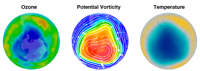
Southern hemisphere total ozone, potential vorticity on the 460 K potential temperature surface, and temperature on the 50 hPa pressure surface for 22 August 2011.
We illustrate the southern polar vortex with three images for 22 August 2011 (similar to the northern polar vortex above). The southern vortex is much stronger and larger than the northern vortex (middle image). The streamlines show wind speeds near 60 m s-1, much greater than would be observed at the comparable time in the northern vortex. Temperatures are also much colder (right image), with values below 190K over a wide region. In contrast, northern temperatures only sporadically fall below 190K over small regions. Ozone levels (left image) are also much different, with low values during the mid-winter period.
The difference between the southern and northern polar vortices is caused by the planetary wave effects discussed above. Large-amplitude planetary-scale wave events that cause warmings are quite frequent in the northern hemisphere. In contrast to the northern hemisphere, the southern hemisphere does not have major mountain ranges (the Andes are tall, but very narrow in longitude) and is mainly a water covered hemisphere. Hence, southern hemisphere forcing of planetary-scale wave events in the troposphere is very weak, and there is an absence of wave events to warm the polar region and erode the polar vortex.
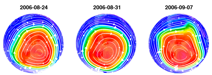
Southern hemisphere potential vorticity on the 460 K potential temperature surface for 24 and 31 August 2006 and 7 September 2006. The white lines with arrows on the PV image are streamlines, where the thickness of the streamlines and the size of the arrows indicate the strength of the local flow.
The PV images above illustrate the lack of large-scale waves in the southern hemisphere during the mid-winter period. Some undulations of PV can be seen along the rim of the vortex. For example, on the right image (7 September 2006) note the “bump” on the vortex rim at about the 1 o’clock postion). However, the vortex is nearly always centered upon the South Pole. This is in remarkable contrast to the northern hemisphere (see images of NH vortex in the section above during January 2010). In addition, note that the southern hemisphere vortex images have much higher PV values (deeper red color) and are larger than their northern counterparts. This is because southern wave events are not present to degrade the strength and area coverage of the southern polar vortex during the mid-winter period.
The lack of planetary-scale wave events in the southern hemisphere leads to a very symmetric polar vortex that is quite strong. Further, because of the lack of erosion of the vortex, it is very persistent. Towards the end of the southern winter season, planetary-scale wave events do begin to form and propagate upward into the stratosphere. These waves erode the vortex, decelerate the jet stream, warm the polar region, and increase ozone levels. While the northern polar vortex usually persists to March or April, the southern vortex persists an additional 1–2 months (November or December). In addition, temperatures remain quite cold (below 195 K) in the southern vortex to early October.
The persistent southern vortex has profound implications for polar ozone loss. Polar stratospheric clouds can form at temperatures below about 195 K. Chemical reactions on the surfaces of the particles that form these clouds convert chlorine compounds from inert forms into highly reactive species. As the sun rises over Antarctica in August and September, visible radiation provides the energy to drive chlorine and bromine catalytic reactions that rapidly destroy ozone. This rapid ozone destruction produces the Antarctic ozone hole.
Of special interest is the southern hemisphere vortex in 2002. That year had the first major warming observed in the southern hemisphere stratosphere. It was a wave-2 warming and the vortex split into two parts.
Vortex breakup
The polar vortex is a winter phenomena. It develops as the sun sets over the polar region and temperatures cool. During the spring, the sun rises and the absorption of solar radiation by ozone begins to heat the polar stratosphere. This heating eventually causes the vortex to disappear along with the polar night jet. However, this process is helped along by planetary-scale waves that propagate up from the troposphere. This wave event that drives the vortex breakup (or final warming) acts to also increase the temperature of the polar region and ozone levels. We mark the day of the vortex breakup when the winds around the vortex edge decrease below a particular value (about 15 m s -1on the 460 K potential temperature surface).
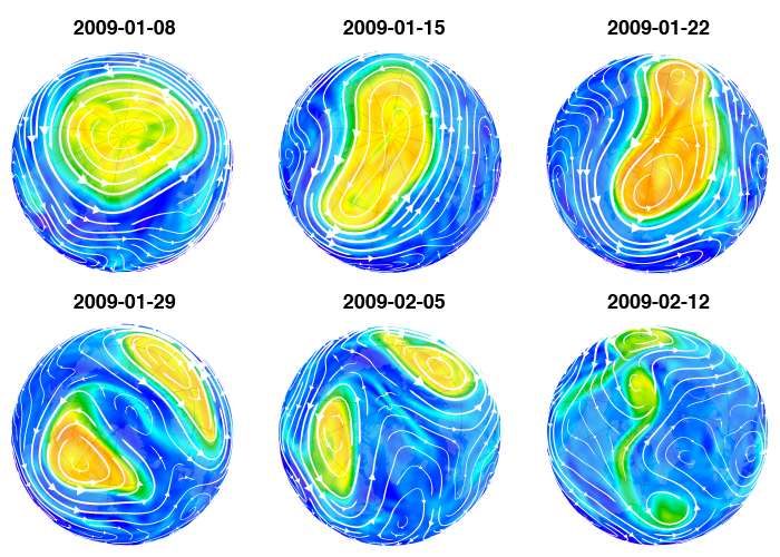
Northern hemisphere potential vorticity on the 460 K potential temperature surface for several dates in 2009.
We illustrate the polar vortex breakup with six PV images from 2009 for 8 January (top left) through 12 February (bottom right). Each image is one week apart. On 8 January the vortex is fairly symmetric. Through the 15th and 22nd the vortex is elongated and displaced off the pole. By the 29th the vortex has split. The vortex weakens, and as can be seen on 5 February, the streamlines show that the winds have decreased in strength. By the 12th, the vortex has completely collapsed. 2009 is a good example of an early final warming.
The northern hemisphere vortex breakup in the lower stratosphere usually occurs late in March or early in April. However, the breakup can occur as early as February or as late as early May. In contrast, the southern hemisphere vortex is more persistent, and the usual breakup occurs late in November to the middle of December (equivalent to late in May to the middle of June for comparison to the northern hemisphere vortex).

